Using Beacons, iBeacons for Real-time Locating Systems (RTLS)
Real-time locating systems (RTLS) are used to automatically identify and track the location of objects or people in real time, usually within a building or other contained area. Beacons are attached to objects or worn by people and fixed gateways or apps receive signals from the beacons to determine their location.
Areas where organisations have used BeaconZone beacons for RTLS include manufacture, warehousing and the tracking of equipment and people. The latter segment has included people on campus, lone workers and evidence based working (e.g. evidence based policing).
Using beacons for RTLS is a sub-set of the sensing implementation type :
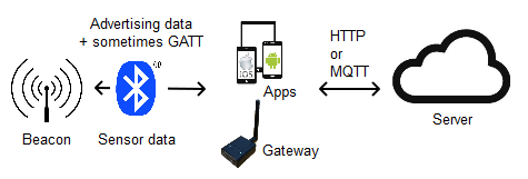
As beacons aren't directly connected to the Internet/Intranet, this requires the use of an intermediate Bluetooth LE device such as a smartphone, single board computer, Ethernet/WiFi gateway or mesh gateway.
For the Ethernet/WiFi gateway case, gateways are placed at known positions. Sometimes this position is just a name, for example 'Warehouse A', but it can also be a lat/long location. Both the gateway and beacons have unique ids. For a beacon-based RTLS, it's often easiest to use the gateway and beacon MAC addresses. Detected beacon ids are uploaded by each gateway. When the server sees the gateway has detected a beacon, it's shown on a map or plan at the gateway position.
If you are tracking people you can use (their) smartphones rather than gateways and place the beacons at known fixed positions. Detected beacon ids are uploaded by each smartphone. When the server sees the smartphone has detected a beacon, it's shown on a map or plan at the beacon position.
The received signal strength (RSSI) is also sometimes uploaded which gives an indication of the distance of the beacon from the gateway or smartphone. In practice, implied distances aren't accurate due to variable radio frequency blocking and reflections. Read more in our article on Determining Location Using Bluetooth Beacons. In some cases, just knowing the asset or person is near the position is sufficient. It's also possible to use angle of arrival (AoA) direction finding to determine more accurate location.
Once proximity data has been received at the server it's shown on plans or maps. It's also possible to create alerts based on the data, forward selected data on to other systems (via HTTP) or consume it within other systems (via REST services).
RTLS need not be complex or costly. The simplest implementations we have created have just output Excel readable files. For more complex solutions consider our BeaconRTLS platform that maps assets/people and provides zone based alerts.
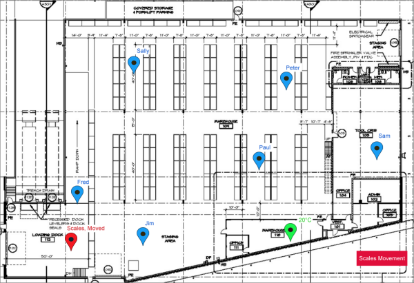
BeaconRTLS showing locations, temperature and (vibration) movement
If you only require the data without maps, our BeaconServer™ can also be used to collect location information.
If you need more specific project help, read about our consultancy.