Using Beacons, iBeacons for Asset Tracking

Tracking things and/or people makes organisations more efficient through enhanced productivity. Most organisations want to improve a specific problem in one of the following areas:

  • Stock Control – Knowing how much you have, where, without any human checking
  • Finding Items – Picking items without time-consuming manual searching
  • Safety & Security – Knowing when assets move, go missing, are dropped or crashed into
  • Process Efficiency – Preventing human error of manual audits, knowing an expensive asset is being fully utilised, providing real time workplace instructions

Having solved a problem, it’s often the case that the act of digitisation allows other problems to be identified and also solved.

There are many ways to track assets using beacons. Beacons can be put on assets and detected by smartphones, Bluetooth gateways, Bluetooth mesh, or other Bluetooth LE devices such as single board computers. Alternatively, beacons can be fixed and the detecting device(s) can move. Software can be in the detecting devices and/or at a server receiving data from the detecting devices. It’s also possible to use a real time locating system (RTLS) to map the positions of assets.

The optimum solution depends on your situation and requirements. Here are some aspects to think about that will determine the optimum solution:

  • What’s the size of area(s) and sub-areas (rooms, zones) you need to cover and is this outside?
  • What’s the physical makeup of the areas (walls, racking) and their composition?
  • What’s the electrical infrastructure (power, WiFi and Ethernet availability) and can this be upgraded?
  • What assets need to be tracked?
  • What attributes of assets need to be tracked (just location or sensor data as well?)
  • How many need to be tracked?
  • How many are in the same place, at the same time?
  • How often do the assets move?
  • How accurate do you need the locating?
  • How up to date do you need the tracking?
  • Who needs to do the tracking, from where?
  • How many people need to do the tracking simultaneously?
  • What kinds of information/report do you require and what’s the desired method of receiving?
  • What existing IT systems have to be integrated?

Contact us if you need help with a complete solution.

Read about Real Time Locating

Read about BeaconRTLS

Read about Asset Tracking for Manufacturers

Hybrid Localisation Method

In our previous article iBeacon Microlocation Accuracy, we wrote about ways of using beacon RSSI to determine location. However, what if you were to use and combine beacon RSSI with other ways of locating to create a hybrid method? This is the topic of a new research Unsupervised Indoor Localization Based on Smartphone Sensors, iBeacon and Wi-Fi by Jing Chen Yi Zhang and Wei Xue of Jiangnan University, School of Internet of Thing Engineering, China.

The paper describes UILoc a system combining dead reckoning, iBeacons and Wi-Fi to achieve an average localisation error is about 1.1 m.

The paper also compares the trajectories obtained using different localisation schemes:

iBeacon Microlocation Accuracy

Customers often ask us the accuracy when locating beacons. In order to get the answer, its necessary to understand different ways of locating and the tradeoffs that are needed to get the different levels of accuracy.

There are two types of locating, received signal strength (RSSI) based and angle of arrival direction finding (AoA).

Locating using RSSI

There are two main scenarios. The first is a where the detector, usually a phone or gateway, is at a known location and the beacon moves. The second is where the beacons are fixed and the detector moves. Either way, the detector receives a unique beacon id and the receiving electronic circuitry provides the strength of the received signal.

The value of the RSSI can be used to infer the distance from the detector to the beacon. The main problem with RSSI is that it varies too much, over time, to be used to accurately calculate distance. The direction also isn’t known when there’s only one beacon and one detector. The varying RSSI, even when nothing is moving, is caused by the Bluetooth radio signals that are reflected, deflected by physical obstacles and interfered with by other devices using similar radio frequencies. Physical factors such as the room, the beacon not uniformly emitting across a range of 360 degrees, walls, other items or even people can affect the received signal strength. How the user holds a detecting phone can affect the effectiveness of the antenna which in turn affects the signal strength.

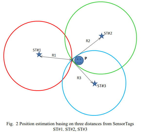
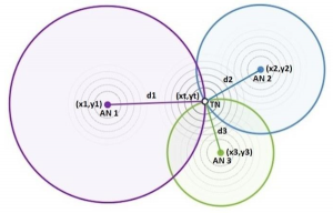
The varying RSSI can be smoothed by averaging or signal processing, such as Kalman filtering, to process multiple RSSI values over time. The direction not being known can be solved by using trilateration where three gateways (or beacons depending on the above mentioned scenario) are used to determine the distance from three directions and hence determine the 2D location.

Trilateration

The aforementioned physical factors that affect RSSI can be reduced by measuring the actual RSSI at specific locations and hence calibrating the system.

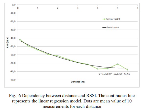
The change of RSSI with distance is greater when the beacon is near the detector. At the outer reaches of the beacon signal, the RSSI varies very little with distance and it’s difficult to know whether the variance is due to a change of distance or radio noise. Hence for systems that use signal processing, trilateration and calibration tend to achieve accuracies of about 1.5m within a shorter range confined space and 5m at the longer distances.

However, such systems have problems. The multiple RSSI values needed for averaging or signal processing mean that you either have to wait a while to get a location fix or have the beacons transmit more often (with a shorter period) that flattens their batteries much sooner. Trilateration requires at least three devices per zone so can be costly and require significant time to setup and maintain. Using calibration is like tuning a performance car. It works well until something small changes and it needs re-tuning. If someone adds a room partition, desk or even something as simple as lots of people in the room, the calibration values become invaid. Re-calibration takes human effort and, pertinently, it’s not always easy to know when it needs re-tuning.

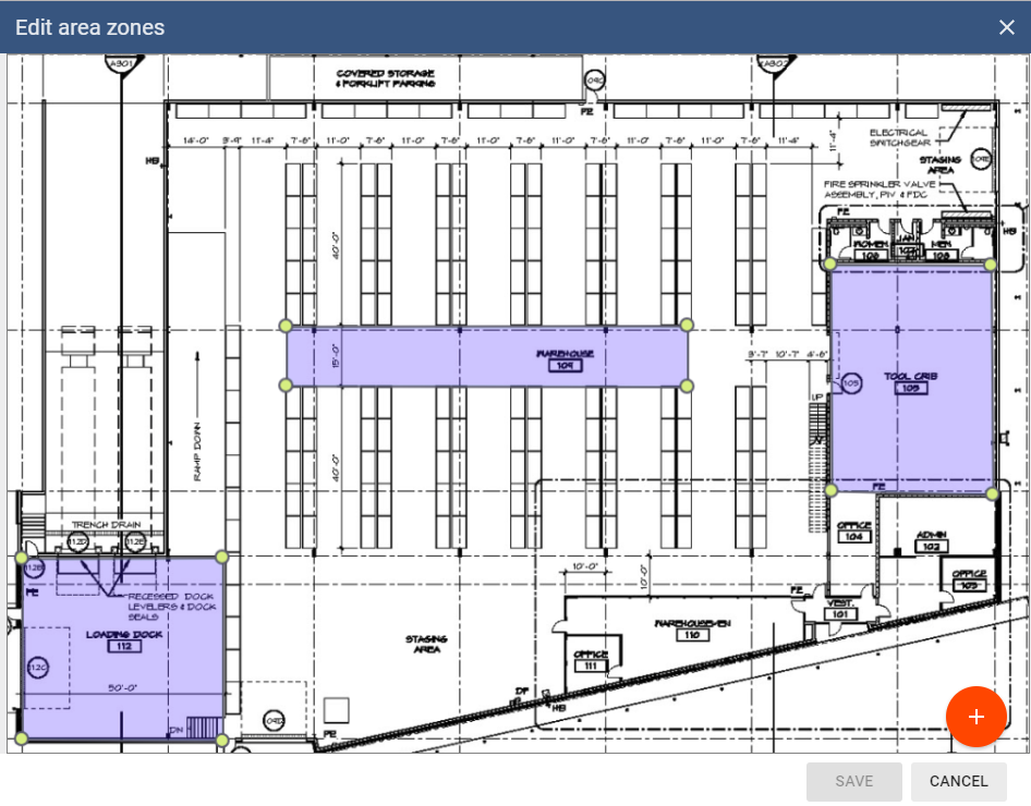
An alternative to trilateration is zoning. This involves putting a detector (or beacon depending on the above mentioned scenario) in each room or zone. The system works out the nearest detector or beacon and can work on just one RSSI value to get a fix quickly. The nearest zone is often all that’s required of most implementations. With zoning, if you need more accuracy in a particular zone you add more detectors in the area to get up to the 1.5m accuracy of other methods. This will obviously be impractical if you need 1.5m accuracy everywhere over a large area.

BeaconRTLS™ area zones

Angle of Arrival Locating

An alternative to trilateration and zoning is more expensive Bluetooth hardware and more complex software that makes use of Angle of Arrival (AoA). Locator hardware with multiple antennas uses Bluetooth Direction Finding to find assets to better than 1m accuracy. Location engine software uses the difference in the time of receiving the signals at multiple antennas to calculate the position. Multiple locators can also be used to cover larger areas and/or improve the accuracy using triangulation.

Unlike RSSI systems where any beacons can be used, locators tend to be tied to using the same manufacturers’ beacons. The complex hardware and software has less throughput and supports fewer beacons. The computing hardware needs to be more powerful. Systems need careful, accurate site measurements to achieve good accuracy.

Summary

Choosing a solution just because it is more accurate, rather than needed, will cost significantly more not just in hardware but in software cost, setup effort and maintenance. Work out what accuracy you need and then seek out an appropriate solution.

Detecting Movement With Beacons

There are various types of movement that can be detected by beacons:

Movement between zones – This is large scale movement between, for example, rooms. This relies on devices detecting the beacons and relaying the information to software that, stores historical location, plots positions and creates alerts. This is the basis for Real Time Locating Systems (RTLS).

Movement from stationary – This is when something goes from being stationary to moving. There are two ways to do this. You can look at the xyz from a beacon accelerometer to determine it has started moving. Alternatively, some beacons such as the iB003 have motion triggered advertising so you will only see the beacon when it moves.

Falling – Again you can look at the xyz from a beacon accelerometer to determine a beacon is falling. Alternatively, you can use a more intelligent beacon such as the iBS01G that does this for you and just gives indications of a start/during/end of a fall as values in the advertising data.

Vibration – The xyz can be used to determine the degree of the movement and hence vibration.

Posture detection – This is more advanced analysis of the xyz that works out, for example, if someone is walking, running, sitting or standing. Another use is the analysis of sports (e.g. golf, squash, tennis, badminton) swings to determine the type of movement and score the movement.

There also scenarios outside the above that are also possible. For example, we had a customer wanting to know if their forklift truck hadn’t been moving for 2 minutes so as to make best use of it.

View our sensor beacons

Have Us Devise a Solution for Your Company

Obtaining Distance from RSSI

RSSI is the signal strength at the Bluetooth receiver. The signal type, for example, iBeacon, Eddystone or sensor beacon is irrelevant. The value of the RSSI can be used to infer distance.

The accuracy of the distance measurement depends on many factors such as the type of sending device used, the output power, the capability of the receiving device, obstacles and importantly the distance of the beacon from the receiving device.

The output power isn’t known to the receiver so it’s sometimes added to the advertising data in the form of the ‘measured power’ which is the power at 1m from the sender.

The closer the beacon is to the receiver, the more accurate the derived distance. As our article mentions, projects that get more detailed location derived from RSSI, usually via trilateration and weighted averages, usually achieve accuracies of about 5m within the full range of the beacon or 1.5m within a shorter range confined space.

There’s some Android Java code on GitHub if you want to experiment with extracting distance from RSSI. There’s an equation for iOS on GitHub.

Need more help? Consider a Feasibility Study.

Beacons that flash/vibrate at a given distance.

Traffic Monitoring Using Bluetooth

There’s a recent story at LA Times on how Newport Beach will monitor drivers’ Bluetooth data to analyze traffic, congestion.

It’s a traffic monitoring system that receives signals from Bluetooth-enabled equipment such as cellphones and in-car hands-free devices, building a real-time picture of motorists’ routes and travel times.

This is a simple example of a real time locating system using Bluetooth devices that are already out there as opposed to, more focused, Bluetooth beacons that are specifically being tracked.

Interview with Ajay Malik, author of RTLS for Dummies

Mr Beacon has a new interview with Ajay Malik, the author of RTLS for Dummies.

It starts with a discussion that tries to define what’s a Real Time Location System (RTLS) in terms of the technologies that can be used. Ajay explains how he ended up working with RTLS and writing the book.

There’s discussion on business drivers and how RTLS relates to machine to machine (M2M) and IoT. Usecases mentioned include promotional marketing, asset tracking and autonomous navigation. There’s a useful explanation of trilateration, triangulation, angle of arrival, time of arrival and time distance of arrival.

Ajay sees asset tracking as currently the most important application. However, going forward, RTLS will feed more into AI to provide context.

Read more about RTLS

Motorola Radios and iBeacons

Motorola manufacture the MOTOTRBO range of digital radios that can detect iBeacons.

Used together with the TRBOnet PLUS (pdf) control room software, the location of people with digital radios can be plotted onto maps:

Supported handsets currently include:

  • MOTOTRBO DP4000e Series
  • MOTOTRBO SL4000e Series
  • MOTOTRBO DP3441e
  • MOTOTRBO DP3661e

Motorola handsets work with any iBeacons. We recently supplied beacons to a power station for lone worker monitoring using TRBOnet PLUS. Buy from our wide range of iBeacons.

Are you an established 2-way radio company?
Contact us for advice on which beacons we have supplied for use with TRBOnet.

New Report on The Proximity & Location Industry

Proximity.directory has a new report on the State Of The Proximity & Location Industry. It’s great to see proximity.directory reports moving beyond retail marketing into asset tracking.

The report gives a great overview of how asset tracking works, the benefits, provides some case studies and lots of charts.

“Hospitals can save hundreds of
thousands dollars a year with an
immediate ROI of 275%”

Download the report.

Research Paper on Using Bluetooth for Indoor Locating

There’s a paper by Mariusz Kaczmarek, Jacek Ruminski and Adam Bujnowski of Gdansk University of Technology on the Accuracy analysis of the RSSI BLE SensorTag signal for indoor localization purposes (pdf).

They studied the radio signal from multiple Texas Instruments SensorTag CC2650 devices in order to determine if it could be used to determine location.

They concluded:

“Given the large number of factors governing the received RSSI, calibration is unlikely to be able to compensate for all of
them, leading us to conclude that there is an inherent limit to the accuracy of a BLE positioning system especially when multiple devices are used.”

They suggest:

…that instead of using a single RSSI measurement to estimate distance, try using the average or median value of N measurements collected on the same spot (at least N>20) so that you can reduce the effect of small scale fading.